Earthquake - 11km - 2018
Description
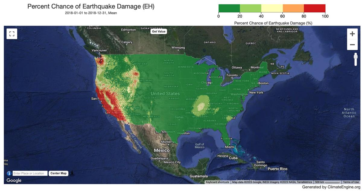
These data represent the chance of experiencing potentially damaging ground shaking for fixed ground shaking levels that corresponds with Modified Mercalli Intensity (MMI) equal to VI, in 100 years. The values are obtained by averaging the probability of experiencing MMI VI based on a peak ground acceleration, and the probability of experiencing MMI VI based on 1.0-second spectral acceleration. Ground motions are amplified using topographic, slope-based Vs30 values (Wald and Allen, 2007). Validity begins in 2018.
Climate Engine details
- Dataset type
- Hazards
- Climate Engine ID
- EH
- Documentation
- https://support.climateengine.org/article/106-earthquake
Dataset details
- Scale
- 11km
- Frequency
- Static
- Coverage
- CONUS
- Start year
- 2018
- End year
- 2018
Earth Engine collection details
- Earth Engine asset
- projects/climate-engine-pro/assets/earthquake_hazard/ProbMMI_VI_100Yrs_VariableVs30
- Earth Engine source catalog
- ClimateEngine.org
Variables
API variable docs: #usgs-earthquake-damage-risk-dataset
| Name | Units |
|---|---|
| Earthquake damage risk | % |
References
- Rukstales, K.S., and Petersen, M.D., 2019, Data Release for 2018 Update of the U.S. National Seismic Hazard Model: U.S. Geological Survey data release, https://doi.org/10.5066/P9WT5OVB.
- Wald, D.J., and Allen, T.J., 2007, Topographic slope as a proxy for seismic site conditions and amplification, Bulletin of the Seismological Society of America, 97(5), 1379-1395
Website: https://www.sciencebase.gov/catalog/item/5cbf47c4e4b0c3b00664fdef
Terms of use
Any use of trade, firm, or product names is for descriptive purposes only and does not imply endorsement by the U.S. Government. Although this information product, for the most part, is in the public domain, it also contains copyrighted materials as noted in the text. Permission to reproduce copyrighted items must be secured from the copyright owner whenever applicable. The data have been approved for release and publication by the U.S. Geological Survey (USGS). Although the data have been subjected to rigorous review and are substantially complete, the USGS reserves the right to revise the data pursuant to further analysis and review. Furthermore, the data are released on the condition that neither the USGS nor the U.S. Government may be held liable for any damages resulting from authorized or unauthorized use. Although the data have been processed successfully on a computer system at the U.S. Geological Survey, no warranty expressed or implied is made regarding the display or utility of the data on any other system, or for general or scientific purposes, nor shall the act of distribution constitute any such warranty. The U.S. Geological Survey shall not be held liable for improper or incorrect use of the data described and/or contained herein. Users of the data are advised to read all metadata and associated documentation thoroughly to understand appropriate use and data limitations.